 An official website of the United States government.
 Official websites use.gov
A .gov website belongs to an official government organization in the United States.
Official websites use.gov
A .gov website belongs to an official government organization in the United States.
 Secure .gov websites use HTTPS
A lock or https:// means you’ve safely connected to the .gov website. Share sensitive information only on official, secure websites.
Secure .gov websites use HTTPS
A lock or https:// means you’ve safely connected to the .gov website. Share sensitive information only on official, secure websites.
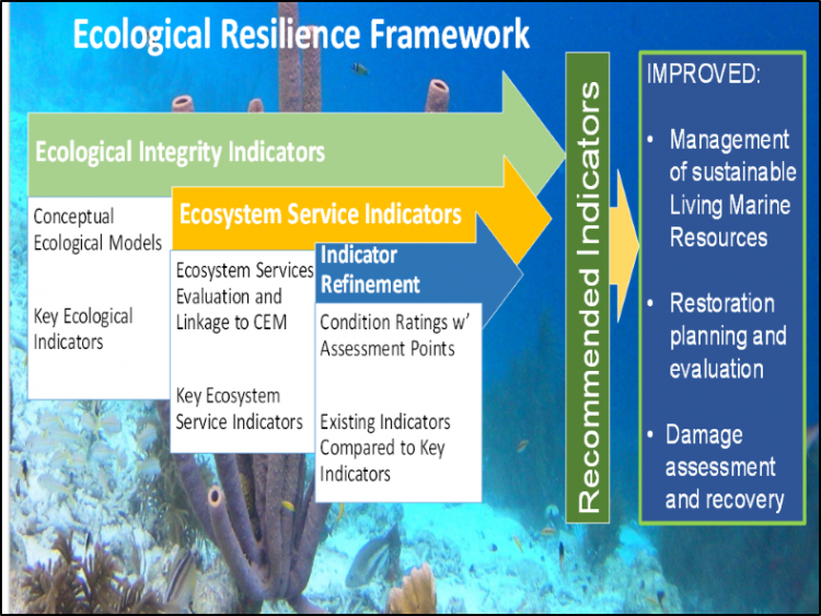
One of NOAA RESTORE Science Program’s first funded projects, Ecological Resilience Indicators for Five Northern Gulf of Mexico Ecosystems, has published it’s final report and web-based decision support tool. The project used an innovative Ecological Resilience Framework (Figure 1) that integrates information on key ecosystem threats (drivers), ecological integrity, and ecosystem services to develop a comprehensive set of ecological resilience indicators for salt marsh, mangrove, seagrass, oyster, and coral ecosystems in the northern Gulf of Mexico. Ecological indicators serve as proxies for characterizing key attributes of ecosystem components. Indicators address both the ecological integrity and ecosystem services of these ecosystems. Ecological integrity is the ability of an ecosystem to support and maintain ecological processes and a diverse community of organisms, and ecosystem services are the many and varied benefits that humans freely gain from the natural environment and from properly-functioning ecosystems.
Steps involved in the indicator development process for all five northern Gulf of Mexico ecosystems included:
- Creating models that identify the critical ecosystem drivers and functions and specify the linkages between them that ultimately effect ecosystem services;
- Using the models to identify indicators that can be monitored to assess the ecological integrity of the ecosystem and its capacity to provide ecosystem services; and
- Developing metric ratings that allow evaluation of ecological condition and capacity for provision of ecosystem services across sites and over time.
For example, in the report ‘Ecological Resilience Indicators for Five Northern Gulf of Mexico Ecosystems – Salt Marshes’ one important abiotic ecological integrity indicator is eutrophication. Practically, eutrophication is measured by calculating total nutrient (nitrogen and phosphorous) load in a watershed. Therefore, environmental managers can use eutrophication as an indicator of salt marsh health by calculating the total amount of nitrogen and phosphorous entering an watershed that drains into a coastal salt marsh. High levels of nitrogen and phosphorous indicate a system undergoing eutrophication, which is likely to negatively impact salt marsh vegetation structure, decrease dissolved oxygen concentrations, and result in poor habitat for valuable fish populations.
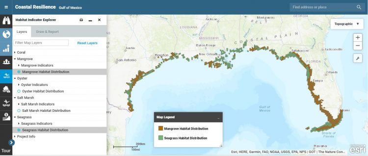
Another step of the project was to evaluate the identified indicators through spatial analysis to determine the degree to which they are currently being monitored by existing programs in the northern Gulf of Mexico. Through this spatial analysis, the project team was able to identify gaps in monitoring and opportunities or needs for additional data collection. The spatial analyses and supporting data for each indicator are published via the Coastal Resilience Decision Support Tool. The decision support tool allows users to overlay habitat distribution and other parameters for the five ecosystems at high spatial resolution (Figure 2). Decision support tool users can zoom in to individual harbors and watersheds, creating fine scale indicator maps for their specific areas of interest.
An executive summary of the report highlights key findings for each of the five ecosystems and the full report is also available at the NatureServe website.