 An official website of the United States government.
 Official websites use.gov
A .gov website belongs to an official government organization in the United States.
Official websites use.gov
A .gov website belongs to an official government organization in the United States.
 Secure .gov websites use HTTPS
A lock or https:// means you’ve safely connected to the .gov website. Share sensitive information only on official, secure websites.
Secure .gov websites use HTTPS
A lock or https:// means you’ve safely connected to the .gov website. Share sensitive information only on official, secure websites.
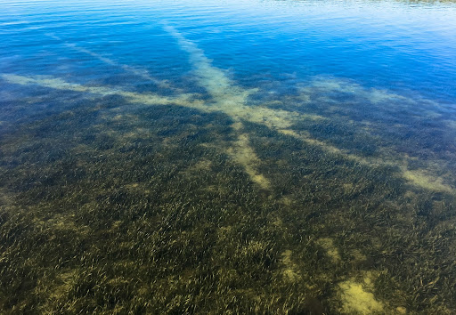
On a warm, sunny day, you snorkel through a lush bed of seagrass. Fish swim between the leaves and crabs crawl across the sediment. Swimming along, you start to notice the seagrass becoming more patchy–almost as if someone has mowed a section away in some spots. There are not as many fish darting out of your way and you see fewer and fewer crabs.
This scene can be experienced across the Gulf of America (formerly Gulf of Mexico), as seagrass extent is rapidly declining. Seagrasses are aquatic plants that thrive in shallow, coastal waters and are ecologically and economically important. Fish such as drum and spotted seatrout live in seagrass meadows while larger animals such as manatees and sea turtles eat the leaves. Unfortunately, a myriad of disturbances such as declines in water quality, increases in storm frequency, and damage from boaters, are driving the decline in seagrass across the Gulf. Given the importance of seagrass meadows, is there anything that can be done to reverse this trend and recover this vital habitat?

Two project teams funded by the NOAA RESTORE Science Program are trying to answer that question in different regions of the Gulf. The ChIRPS project (Chandeleur Islands Restoration Project for Seagrasses), led by Dr. Kelly Darnell, is assessing the resilience capacity of seagrasses through the collection of biological and physical data in the Chandeleur Islands off the coast of Louisiana. The SCARMAPS project (Seagrass Conservation through Actionable Research – Management Areas for the Prevention of Scarring), led by Dr. Savanna Barry, is working on the Nature Coast of Florida to identify boat propeller scars and their effects on seagrass beds to inform management actions.
Chandeleur Islands restoration
The Chandeleur Islands, part of the relic St. Bernard Delta, are a chain of barrier islands about 40 kilometers off the coast of Louisiana. They are home to several important and federally protected animals such as piping plovers, Kemp’s ridley sea turtles, and Gulf sturgeon. They also contain the largest and most diverse assemblage of seagrasses in the northern Gulf and are the only seagrasses found in Louisiana.
The islands act as the first line of defense from major storms that travel through the area. As a result, they are rapidly eroding and are expected to be completely underwater in 20 years if no efforts are taken to restore the area. “The seagrasses that grow out there rely on the islands for protection from waves… so as the islands are disappearing, the seagrasses are disappearing as well,” Darnell explained. Darnell, a faculty member at The University of Southern Mississippi (USM), Director of USM’s Gulf Coast Research Lab, and Director of the Mississippi Based Restore Act Center of Excellence, has been working in the Chandeleur Islands since 2015.
Louisiana’s Coastal Protection and Restoration Authority (CPRA) is currently in the design phase of the Chandeleur Islands Restoration project, which plans to restore the 13-mile-long island. This plan focuses on whole ecosystem restoration, including the restoration and enhancement of seagrasses. “Our project is essentially to maximize benefits of the restoration project for the seagrasses growing along the islands,” Darnell said. However, because the islands are so remote, very little is known about the system. Darnell and her team have several interconnected studies to understand the condition of Chandeleur Island seagrasses.
Darnell and her PhD student, Caitlin Young, are responsible for the long-term monitoring of the seagrass meadows over time. They will record which seagrass species are present and how much seagrass there is at over 100 locations along the island chain every year for the duration of the project. These data will provide baseline information on seagrass changes, and “if a storm passes we’ll be able to sample before and after the storm to evaluate impacts,” Darnell said.
This monitoring effort will be complemented by genetic sampling of Chandeleur seagrasses to assess their capacity to be resilient and bounce back from disturbance. Measuring genetic diversity within an ecosystem is important because “a more diverse ecosystem is better able to withstand disturbance,” Darnell said. In more diverse populations, there is a greater likelihood that at least some of the population will survive if stressful environmental conditions occur.
Dr. Laura Reynolds, an associate professor at the University of Florida, is leading this effort. Reynolds is a co-investigator on both the ChIRPS and SCARMAPS projects and plays a vital role in each. For the ChIRPs project, she will collect seagrass plants at the same spots that are being monitored and extract their DNA. Using the plant’s DNA, Reynolds can measure genetic diversity across the Chandeleur Islands to assess resilience capacity.
Nature Coast propeller scar mapping
About 400 miles southeast of the Chandeleur Islands, Barry and her team are working diligently on Florida’s Nature Coast. The Nature Coast encompasses 800 square miles of coastal waters and contains a diversity of habitats including oyster reefs, mangrove forests, and salt marshes. The large expanse of shallow waters make the area ideal for seagrasses and contains the largest contiguous seagrass meadow in the Gulf.
The Nature Coast is a popular destination for recreational fishers since it is home to snook, spotted seatrout, and redfish. Unfortunately, if the fishers are not careful when boating through seagrass beds, they can cause what are known as propeller scars. This happens when a boat’s motor contacts the bottom of the seafloor and cuts through the seagrass meadow. “We call it a scar because it is pretty lasting,” Barry said. “Scars normally impact the root systems of the seagrass.” It can take up to 60 years for the seagrass to grow back after a scar.
Propeller scars are a widespread issue, but are “exponentially increasing” on the Nature Coast, Barry said. With a record number of boats being registered during the COVID-19 pandemic, propeller scarring has become so severe across the area that additional management actions and regulatory interventions may be needed.
To make these decisions, natural resource managers at the Florida Department of Environmental Protection need updated maps of where propeller scars are, but the most recent maps they have are from 1995.
Barry and her team first plan to update the propeller scar maps for the Nature Coast in collaboration with the local Water Management District. They are using drone and aerial imagery to assess where the worst scarred areas are and how scar density has changed over time. This first effort will inform several other parts of the project.
Some members of Barry’s team, including Reynolds, will be conducting surveys to investigate the ecology of the scars. They have identified “scars that we’re monitoring twice a year for three years,” Reynolds said. The team will conduct fish trawls and invertebrate collections to assess how the fauna of the area are responding to the scars. They will also assess the impact of scars on the sediments themselves and the carbon and nutrients that they store.
In addition to studying the seagrass meadows and the fish that use this vital habitat, Barry also plans to explore the human side of this issue. Team members will be conducting interviews with fishers at boat ramps to assess their perceptions and knowledge of propeller scars and answer questions surrounding the economics of management zones. They plan to ask questions such as “If you weren’t allowed to use your motor in this area, would you still fish here?” From past survey efforts, the team knows that fishers value seagrasses and are aware of the risk of propeller scars. Now, they are trying to take additional steps to protect and restore the seagrass meadows.
Using technology to enhance restoration
Both the ChIRPS and SCARMAPS teams are using advanced mapping technologies to deepen their understanding of seagrass loss over time and support planning for restoration.
Barry and her team are using drones and aerial imagery to update propeller scar maps for the Nature Coast. Using these maps, the project team has been able to identify spatial differences in the intensity of propeller scarring throughout the Nature Coast. They can also determine what type of vessel caused the scar.
However, for many agencies, updating their scar maps can be prohibitively expensive and time-consuming. Even if drone use is accessible for an agency, someone has to process the images and identify scars. Scientists on Barry’s team are working to develop an artificial intelligence (AI) tool to automatically detect propeller scars. This will significantly cut down on processing time, which will make mapping propeller scars easier for natural resource managers. The scientists on Barry’s team have indicated that this method may work for imagery with a lower resolution such as aerial or satellite imagery as well.
Similarly, scientists on the ChIRPS team are using remotely sensed imagery from satellites to detect changes in seagrass cover over time. The regular monitoring of seagrass species and changes in the amount of seafloor covered by seagrass is very important for detecting declines in the condition of a meadow. However, this can be difficult on remote islands such as the Chandeleurs.
Dr. Alicia Sendrowski, a remote sensing scientist at The Water Institute, is using machine learning to create a seagrass detection model. Using publicly available satellite imagery, Sendrowski has been able to accurately identify seagrass species and cover of Chandeleur Island’s seagrass going back to the 1980s. Dr. Bingqing Liu, an assistant professor at the University of Louisiana at Lafayette, has shown that spectral analysis of high resolution, commercial data can identify seagrass on a species level.
The maps created by Sendrowski and Liu will be used in combination with hydrodynamic modeling to determine the cause of seagrass decline at the Chandeleurs. The hope is that these tools will be able to replace the need for extensive human monitoring, significantly cutting down on the time and resources required to keep an eye on this important habitat.
Intentional co-production
All projects funded by the Science Program need to have at least one natural resource manager on the team and be co-produced. Co-production is the collaboration of researchers, resource managers, and other resource users across the scoping, design, execution, and application of a research project with the end result of informing a specific natural resource management decision.
Since both the ChIRPS and SCARMAPS projects have direct applications to seagrass management and restoration, co-production fits in well with the way Darnell and Barry think about their science and its use. “We have been doing co-production since before it was called that,” Barry said. “Pretty much all of the work I do has a restoration or conservation focus and is enhanced by partnering with end-users of the data,” Darnell said.
Members of both project teams noted how smoothly the co-production process is going due to the intentional work the teams put into the planning process of their projects and building long-term relationships with natural resource managers. Barry had been working on efforts to educate boaters about propeller scars in collaboration with resource managers for eight years prior to the start of her current project. “We already have such a high level of trust,” Barry said. “When you’re trying to produce science for managers to act on, you almost can’t help but co-produce it, or else you could end up just wasting a lot of time.”
Similarly, Darnell has been working with managers long before her current project. She strives to be a trusted source for managers and is eager to share her data to help them make informed decisions. “Everyone’s got a mutual interest, everyone wants to be there, and that makes a difference,” said Todd Baker, a project manager at CPRA and the natural resource manager on the ChIRPS project. It is clear that for both project teams the relationships between the researchers and natural resource managers will extend well beyond the length of their current projects.
Both projects have such strong ties to management applications that “neither of these projects would happen outside of the co-production realm,” Reynolds said.
The field season for the ChIRPS and SCARMAPS teams is coming up as the prime seagrass growing season is June to October. Members of the ChIRPS team are excited to continue monitoring this season and begin a study to examine seagrass reproductive output. The SCARMAPS team is ready to fly drones over seagrass beds and conduct ecological surveys within a propeller scar. If you are enjoying the waters of the Chandeleurs or the Nature Coast this summer, keep an eye out for these teams and do your part to make sure these seagrass meadows are around for many more years to come.