 An official website of the United States government.
 Official websites use.gov
A .gov website belongs to an official government organization in the United States.
Official websites use.gov
A .gov website belongs to an official government organization in the United States.
 Secure .gov websites use HTTPS
A lock or https:// means you’ve safely connected to the .gov website. Share sensitive information only on official, secure websites.
Secure .gov websites use HTTPS
A lock or https:// means you’ve safely connected to the .gov website. Share sensitive information only on official, secure websites.
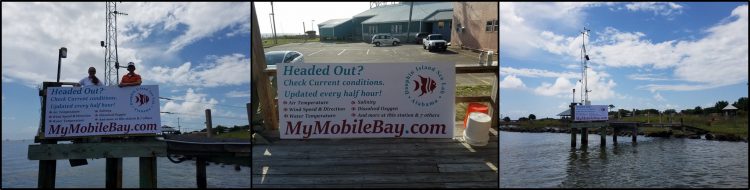
Heading Out? You’ll see a new sign at the mouth of Mobile Bay connecting boaters and other visitors to mymobilebay.com (now known as ARCOS, https://arcos.disl.org/). The user-friendly, web-based portal serves observations updated every 30 minutes from the Alabama Real-time Coastal Observing System (ARCOS), and is a valuable source of real-time weather and water conditions for anyone who wants to enjoy or make their living out on the waters of the Bay.
With support from the National Oceanic and Atmospheric Administration’s (NOAA’s) RESTORE Science Program, the Dauphin Island Sea Lab has expanded the spatial and temporal coverage of the Alabama Real-time Coastal Observing System (ARCOS) and is ensuring its high-quality and system-wide information reaches those who need it through ARCOS. Upgrades include modernizing four observing stations to enhance their reliability, the addition of real-time water clarity observations, new procedures for automatically ingesting and displaying data, and the addition of real-time measurements of salinity, temperature, and dissolved oxygen at an offshore station just outside the mouth of the Bay. With over 7000 unique users a month, these upgrades are improving the quality and quantity of information available to support coastal management, fisheries, commercial shipping, and recreational use in Mobile Bay.
A shallow bay with the fourth largest drainage system in the U.S., Mobile Bay is a dynamic system where water conditions at one location can change rapidly. By providing real-time weather and water information, including air and water temperature, wind speed and direction, salinity, and dissolved oxygen, the Alabama Real-time Coastal Observing System allows those who use the Bay to make the most of their time on the water and do it safely. Information is updated every half hour and is gathered from seven water quality sampling stations located around Mobile Bay and one station outside the mouth of the Bay. Whether it is finding the favored water conditions of the fish you want to catch or wildlife you want to see, planning a restoration activity, safely moving cargo up the ship channel, or just enjoying a day out on the water, the expanded observing system and its web portal help make it happen.
By funding projects like this one, the NOAA RESTORE Science Program aims to increase our understanding of the Gulf of Mexico ecosystem and to provide resource managers and other end users with the best available scientific information and products to ensure its sustained use by current and future generations.
The new sign is located at the busiest launch in coastal Alabama – Billy Goat Hole on Dauphin Island – and was installed in time to take advantage of red snapper season and the associated uptick in boat traffic. In 2017, scientists conducted a survey to assess the number of fishers leaving out of Mobile County across 10 days in May and June. Only one sampling day was within federal snapper season and there were more fishers on that day than the other nine days combined. The mymobilebay.com sign is also visible to anyone riding the ferry, traveling on a charter vessel, or living in the northeastern part of Dauphin Island with water access.