 An official website of the United States government.
 Official websites use.gov
A .gov website belongs to an official government organization in the United States.
Official websites use.gov
A .gov website belongs to an official government organization in the United States.
 Secure .gov websites use HTTPS
A lock or https:// means you’ve safely connected to the .gov website. Share sensitive information only on official, secure websites.
Secure .gov websites use HTTPS
A lock or https:// means you’ve safely connected to the .gov website. Share sensitive information only on official, secure websites.
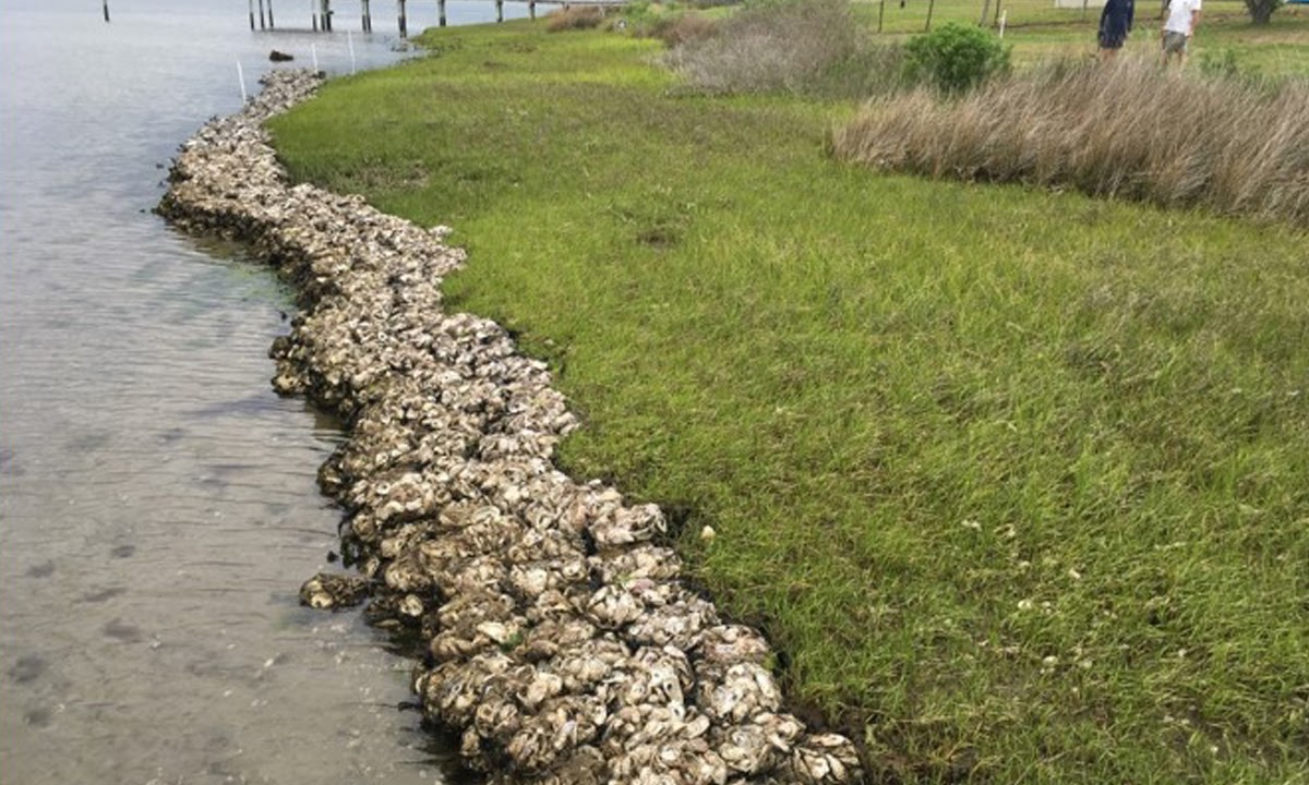
When coastal landowners along the Gulf of Mexico see signs of shoreline erosion, they can soon turn to a new online tool for recommendations on how to protect their property and coastal resources at the same time with a living shoreline. A project team from Troy University, Geological Survey of Alabama, Galveston Bay Foundation, and Virginia Institute of Marine Science, funded by NOAA’s RESTORE Science Program, is customizing a computer model for simulating the suitability of using a living shoreline to specific locations along the Gulf Coast. The interactive, online decision support tool is linked to the customized models so that accessing the models’ results will be easy. This model and tool combination will help promote the wise use of living shoreline protection options by federal and state agencies, homeowners, marine contractors, natural resource managers, and city planners. A living shoreline uses native vegetation alone, or in combination with stone, sand, or other structural and organic materials, to stabilize a shoreline while also letting natural functions take place. A living shoreline allows for the natural movement of water and sediment while controlling erosion, reducing nutrient pollution, providing essential habitat for aquatic creatures, and providing a more natural buffer to protect shorelines from waves and storms. A living shoreline provides long-term protection, restoration, or shoreline enhancement without severing the connection between upland and aquatic areas. Living shorelines are in contrast to hard shorelines that use seawalls, breakwaters, or revetments to counter waves and storms.
The computer models, developed by the Virginia Institute of Marine Science and applied to the Gulf Region by the project team, build on existing work that has been completed for Mobile Bay, AL and Tampa Bay, FL by groups funded through the Gulf of Mexico Alliance. In addition to those water bodies, models are also being developed for Lake Pontchartrain, LA; Perdido Bay/Wolf Bay/Ono Island Complex, AL; and Galveston Bay, TX. The online tool allows any person to interact with the basic principles of the computer model for their water body using a question and answer format. The person using the tool will then receive a series of shoreline best management practices and options for implementation at a much finer geographical resolution than previous models. So now coastal landowners can easily access recommendations for nature-based erosion control solutions and for future restoration projects tailored to their site.
To make sure the models and online tool meet users’ needs and to promote use of the tool, the project team has taken several steps. At the start, the project team created advisory boards for each waterbody to obtain direct input from stakeholders. This step helped to ensure that many questions and concerns were identified and addressed before the model and tool was launched in each region. In addition, workshops are being conducted in each waterbody to promote use of the tool among coastal landowners. Finally, a manual is being written to allow for replication and customization of the model that underlies the online tool for other regions of the country. The project team anticipates the tool will be showcased through NOAA’s Digital Coast Tools portal when the project is complete.
Until then, check out the beta version of the tool and attend one of the upcoming workshops when the project team comes to your area.
Upcoming Living Shoreline Decision Support Tools Workshops
Coastal Louisiana Living Shorelines Tools Workshop
When: 4 February 2020 at 9 a.m. to 1 p.m. (Lunch provided)
Where: University of New Orleans, Earl K. Long Library, Room 407, 2000 Lakeshore Drive, New Orleans, LA 70418
Cost: Free – (registration required)
Register: https://lakepontchartrainlivingshorelinedecisionsupport.eventbrite.com
Contact: Niki Pace (nlpace@lsu.edu) or Dr. Chris Boyd (boydc@troy.edu)
Galveston Bay Living Shorelines Decision Support Tools Workshop
When: Late April or May
Contact: Lee Anne Wilde (lwilde@galvbay.org) or Dr. Chris Boyd (boydc@troy.edu) to be put on an invitation list.
Written by Pete Key