 An official website of the United States government.
 Official websites use.gov
A .gov website belongs to an official government organization in the United States.
Official websites use.gov
A .gov website belongs to an official government organization in the United States.
 Secure .gov websites use HTTPS
A lock or https:// means you’ve safely connected to the .gov website. Share sensitive information only on official, secure websites.
Secure .gov websites use HTTPS
A lock or https:// means you’ve safely connected to the .gov website. Share sensitive information only on official, secure websites.
The NOAA RESTORE Science Program is leveraging cutting-edge technologies and collaboration to deepen understanding of the Gulf of America’s (formerly Gulf of Mexico) complex ecosystem, providing vital data to natural resource managers. Across a diverse portfolio of projects funded by the Science Program, project teams are using artificial intelligence, genetic tools, submersibles, drones, and satellite tags to monitor marine life and habitats, enhancing resource management and restoration in the region.
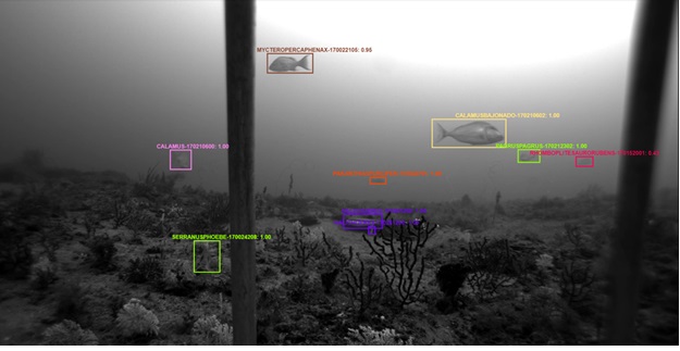
The Gulf Fishery Independent Survey of Habitat and Ecosystem Resources or G-FISHER project led by Ted Switzer at the Florida’s Fish and Wildlife Research Institute is exploring new ways to track fish populations in the Gulf using automation and machine learning. Central to the effort is a tool called Video and Image Analytics for a Marine Environment (VIAME), software that can scan underwater video and help identify and count over 150 species of reef fish. Trained on a large collection of underwater images, VIAME supports researchers by speeding up the process of analyzing footage from hundreds of survey sites. This helps produce more consistent data on fish abundance across the Gulf. While not yet perfect, the system is improving over time and offers a practical way to handle large volumes of data and complement human readers. Continued development of VIAME will further reduce the time it takes to get estimates of fish abundance into the hands of fisheries managers so they can be more confident in their decisions.
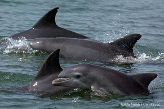
A project team led by Ryan Takeshita at the National Marine Mammal Foundation is using machine learning combined with genetic sampling to understand how healthy a dolphin is just by looking at its DNA. Working with dolphins in the Houston area, they’re using a technique from human aging research to study epigenetic markers—tiny chemical changes to DNA that act like biological time stamps. These markers can reveal not just a dolphin’s age, but how much wear and tear it’s experienced from things like stress, disease, or pollution. By comparing these DNA clues from skin samples to levels of industrial chemicals like polychlorinated biphenyls (PCBs) and dioxins in Galveston Bay, researchers are investigating whether pollution is causing dolphins “to age” faster than they should. To help make sense of it all, machine learning models—trained on data from hundreds of dolphins—are uncovering patterns that might otherwise go unnoticed. The findings could shape how researchers monitor dolphin health in the future and help protect these animals from the hidden effects of a changing environment.
Genetic tools are also being used to discover connections in much deeper waters (50 to 2600 m) in the Gulf. Using robotic submersibles, a team of researchers led by Santiago Herrera at Lehigh University set out to understand how populations of deep-sea corals are connected across vast underwater landscapes—an essential piece of the puzzle for protecting these habitats. The team collected coral samples from the depths of the Gulf and used DNA barcoding and genomic sequencing to map the genetic fingerprints of these corals. This allowed them to measure how connected coral populations are across different sites—essentially tracking how genes flow through the ocean. But genes don’t tell the whole story—so the researchers also turned to ocean physics. Using a computer model that simulates ocean currents, they tracked the journeys of virtual coral larvae, drifting for weeks through simulated waters. These simulations helped explain how young corals might travel from one location to another, shedding light on the invisible ‘underwater highways’ that connect distant coral communities. By blending technologies from biology and oceanography, this project revealed how deep-sea corals maintain connections across the Gulf and offered critical insight into how they might recover from damage—and how best to protect them for the future.
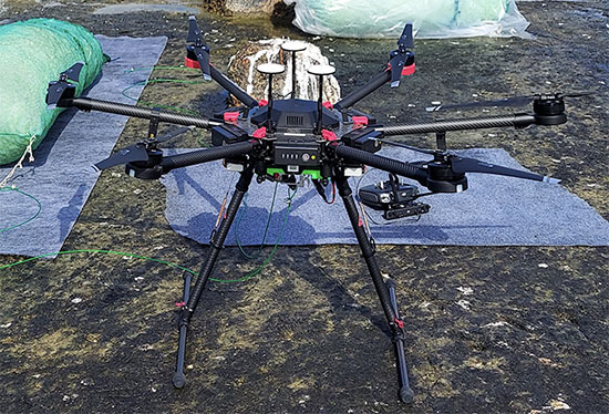
From vehicles remotely piloted through water to ones remotely piloted through the air, project teams are putting technology to use for the well-being of the Gulf. Oil spills are a threat to marine life and coastal communities—especially along busy waterways like Galveston Bay. To get ahead of the next spill, a project team led by Scott Socolofsky at Texas A&M University is taking to the skies with drones to spot oil slicks and track surface currents in real-time. The idea? Use aerial data to supercharge NOAA’s oil spill prediction system, so responders know exactly where the oil is headed—and how to stop it. But the innovation does not stop there. The team is also creating a response effectiveness index, a new decision-making tool, that will combine the improved survey information from the drones with computer modeling to develop maps that rank oil slicks by their priority for response in order to maximize protection of coastal natural resources and help emergency managers respond faster and smarter when every second counts.
While sometimes you can buy the new technology you need, sometimes you just have to build it yourself. That is what another project team led by Michael Moore at Woods Hole Oceanographic Institution and Randall Wells at Brookfield Zoo Chicago’s Sarasota Dolphin Research Program has done. In the vast expanse of the Gulf, understanding the movements and habitats of dolphins that spend most of their time far from shore is crucial for their conservation. Traditional methods of tracking these intelligent marine mammals often involve capturing and handling, which is expensive and can be dangerous for the dolphins and the researchers. Enter an innovative tagging approach aiming to change the game. By using a specially designed and fabricated pole, called a “TADpole” (tag attachment device on a pole), the project team can remotely affix satellite-linked tracking tags to free-swimming dolphins riding at the bow of a boat, such as Atlantic spotted dolphins, allowing for the collection of vital data on their movements, diving behaviors, and habitat use and opening the door to studying dolphin populations that were previously difficult to monitor. By shedding light on how these dolphins navigate and utilize different habitats, this research provides essential information for developing effective conservation strategies.
As marine research in the Gulf dives into a new era of high-tech tools—from artificial intelligence to underwater and aerial drones —what truly makes these innovations powerful is the collaboration behind them. When researchers team up with resource managers, it’s not just about using cool technologies to collect data—it’s about asking the right questions and finding ways to get resource managers the information they need to make decisions. Together, they turn technology into action, transforming complex science into smart strategies that manage and restore the Gulf.