 An official website of the United States government.
 Official websites use.gov
A .gov website belongs to an official government organization in the United States.
Official websites use.gov
A .gov website belongs to an official government organization in the United States.
 Secure .gov websites use HTTPS
A lock or https:// means you’ve safely connected to the .gov website. Share sensitive information only on official, secure websites.
Secure .gov websites use HTTPS
A lock or https:// means you’ve safely connected to the .gov website. Share sensitive information only on official, secure websites.
Join us on April 3 at 1 pm ET for our next seminar in our Planning for Actionable Science in the Gulf of Mexico series.
In 2023, 10 projects were funded by the NOAA RESTORE Science Progam’s Actionable Science competition to conduct previously planned research in the Gulf of Mexico. Though each project conducted a collaborative planning process prior to receiving this funding, that process varied greatly from team to team. This seminar series will highlight the variety of approaches to planning applied research that were taken by each team. Planning activities include holding workshops to convene interested parties, conducting preliminary research to identify research gaps, and building relationships among team members to support better communication throughout the project.
Join this series to hear lessons learned from teams that have prioritized collaborative processes in their research planning. For more information on the 10 projects funded, visit the award announcement.
Our first seminar will take place TODAY! We will be joined by Dr. Nicole Michel and Dr. Simon Brandl at 2 pm ET. It’s not too late to register here.
Next, we will be joined by Dr. Savanna Barry and Dr. Kelly Darnell on April 3 at 1 pm ET. See more details about their presentations below.
Dr. Kelly Darnell, University of Southern Mississippi Gulf Coast Research Laboratory
Co-Producing Science to Maximize Benefits of Large-Scale Ecosystem Restoration of the Chandeleur Islands, LA through the Protection and Enhancement of Seagrass Habitat
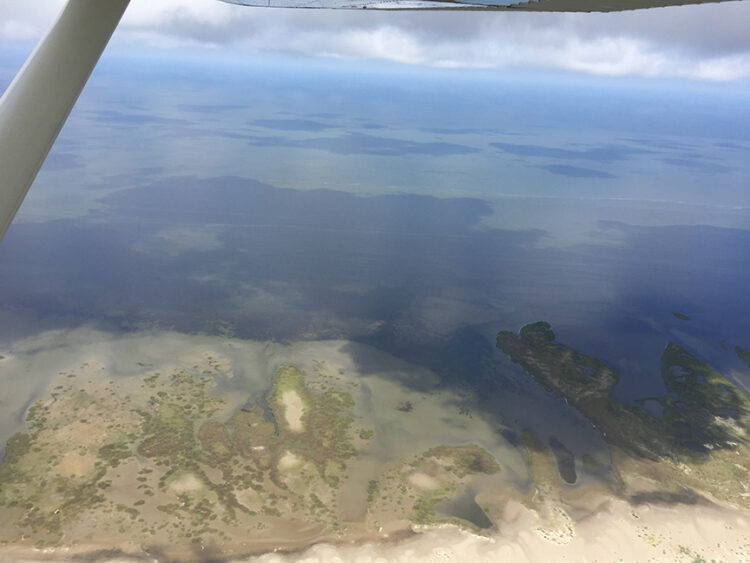
The Chandeleur Islands are a hotspot for plant and animal diversity in the northern Gulf of Mexico. The islands support the only marine seagrass beds in Louisiana, which grow along the shallow, protected side of the islands. The Chandeleur Islands are disappearing and, without targeted restoration, are projected to transition to a shoal by 2037 primarily due to inadequate sand supply, sea level rise, and feedback processes resulting from the passage of major storms. The project team is using a co-production framework to collect spatially and temporally explicit data for seagrasses at population and landscape levels, conduct responsive sampling to determine disturbance impacts, and build on existing numerical models to better connect the physical and biological systems and assess seagrass resilience capacity. The project will provide guidance for restoration of the Chandeleur Islands and will inform a long-term monitoring and adaptive management plan. Findings and products are expected to include spatially discrete data and species distribution maps of historic, current, and potential seagrass cover under a range of conditions, as well as a list of recommended seagrass restoration success criteria. Learn more about the project here.
Dr. Savanna Barry, Florida Sea Grant and University of Florida Institute of Food and Agricultural Sciences Extension
Seagrass Conservation through Actionable Research: Management Areas for the Prevention of Scarring
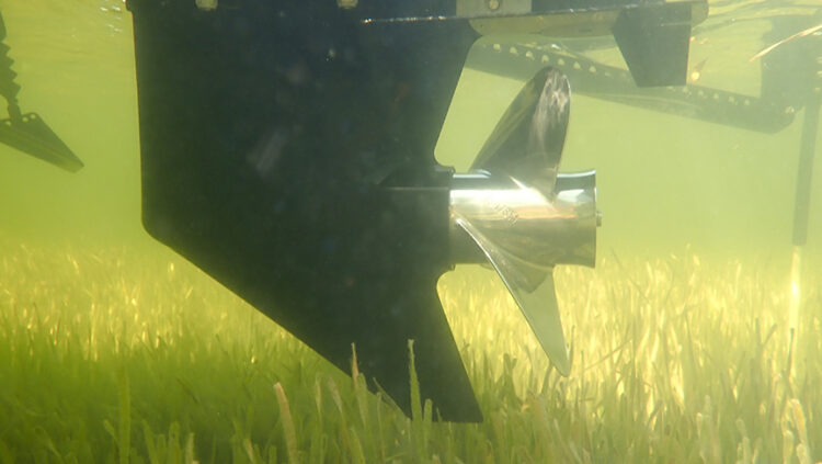
Damage to seagrasses by propeller scarring in aquatic preserves of Florida’s Nature Coast is a growing issue that is of increasing concern to managers and stakeholders. A recent stakeholder workshop series resulted in a management plan for the newly designated Nature Coast Aquatic Preserve. Stakeholders repeatedly identified propeller scars as a priority issue by outlining at least 10 actionable strategies related to propeller scarring and seagrass protection in the plan. At the same time, the for-hire fishing sector raised concerns regarding the intensification of propeller scarring within the adjacent St. Martins Marsh Aquatic Preserve. This led to a co-produced feasibility study that identified trends in fishing and boating pressure, tested processes for mapping scarring hotpots, and outlined policy options and research needs for addressing propeller scarring. These collaborative scoping efforts identified a suite of possible management actions, but managers lack the data needed to inform specifically how and where to act. The SCAR MAPS project recently funded through the RESTORE Science Program’s Actionable Science call will collect geographic, biological, logistical, and socioeconomic data to pair with stakeholder guidance through a co-production model to address data gaps and enable multiple decisions and management actions to move forward. Our team will collaborate with managers and stakeholders to produce products such as updated propeller scar maps, recommendations for economically and ecologically optimized spatial zoning, and a restoration plan for the most severely scarred seagrass flats. Learn more about the project here.